Santa Croce di Magliano
| Santa Croce di Magliano | |
|---|---|
| — Comune — | |
| Comune di Santa Croce di Magliano | |
|
Santa Croce di Magliano
|
|
| Coordinates: | |
| Country | Italy |
| Region | Molise |
| Province | Province of Campobasso (CB) |
| Area | |
| • Total | 52.6 km2 (20.3 sq mi) |
| Elevation | 608 m (1,995 ft) |
| Population (Dec. 2004) | |
| • Total | 4,863 |
| • Density | 92.5/km2 (239.5/sq mi) |
| Demonym | Santacrocesi |
| Time zone | CET (UTC+1) |
| • Summer (DST) | CEST (UTC+2) |
| Postal code | 86047 |
| Dialing code | 0874 |
| Website | Official website |
Santa Croce di Magliano is a comune (municipality) in the Province of Campobasso in the Italian region Molise, located about 30 km northeast of Campobasso. As of 31 December 2004, it had a population of 4,863 and an area of 52.6 km².[1]
S. Croce di Magliano is situated on a hilltop approximately 608 m. above sea level, just north of the Fortore river. In the Middle Ages the Roman settlements gave rise to "casali", or rural hamlets, and in the Swabian period (13th century) Santa Croce is recorded as a fiefdom of the Stipide family.[2] In 1266 it became a fiefdom of the Monastery of Sant'Eustachio[3].
Santa Croce di Magliano borders the following municipalities: Bonefro, Castelnuovo della Daunia, Montelongo, Rotello, San Giuliano di Puglia, Torremaggiore.
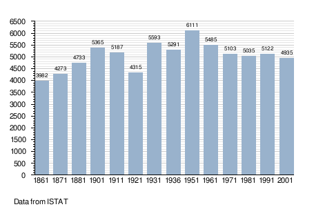
Demographic evolution

|
|||||||||||||||||||||||
References
- ^ All demographics and other statistics: Italian statistical institute Istat.
- ^ Italy World Club, Santa Croce di Magliano (accessed January 11 2009)
- ^ http://it.wikipedia.org/wiki/Santa_Croce_di_Magliano (accessed January 11 2009)
External links
- City of Santa Croce di Magliano
- official site (in Italian)
- www.santacroceonline.com (web magazine; in Italian)
- The Origin and Legends of S. Croce di Magliano